Contact us

  • Postal addressGlasgow, Edinburgh, Ayr, Dundee and Lanarkshire
  • Phone NumberClick here to call us
  • Emailinfo@dronescotland.com
  • Facebook
  • Instagram
  • Linkedin
  • Youtube
  • Vimeo
Skip to content
Drone Scotland
Menu
  • Services
    • All Services
    • Aerial LiDAR Surveys: Precision Mapping for the Future
    • Photogrammetry, Survey and Topography
    • Construction Drone Services
    • Housebuilding
    • Thermal Survey
    • Infrastructure Surveying
    • Aerial Inspection/Drone Survey
    • Timelapse photography
    • Photography & Videography
    • Video Production Services – Drone Scotland
    • TV & Commercials
  • Gallery
    • Video
    • Photogrammetry, Survey and Topography
    • Aerial Inspection/Drone Survey
    • Drone Photography
    • 360 Degree Panoramas
    • Stock Images
      • STOCK LICENSING AGREEMENT
  • Blog
  • About
    • About
    • Contact
      • All Offices
      • Glasgow
    • Meet the Team
    • Links
    • FAQ
    • Website Terms and Conditions
    • Modern Slavery Statement
    • Recruitment
  • Rates
  • Equipment
    • Matrice M300 RTK
    • Mavic 3 RTK Multispectral
    • Mavic 3 Thermal
    • Phantom 4 RTK
    • Mavic 3 Cine
    • Mavic 2 Pro
    • Mavic 2 Enterprise Dual
    • DJI Phantom 4 Pro
    • Mini 4
  • Equipment for Sale
    • Unused DJI M300 RTK Enterprise – £6,000
    • DJI Phantom 4 RTK (including DRTK2 and tripod)
  • CPD

Category: LiDAR

Drone Scotland > Blog > LiDAR
Construction / Housebuilding / LiDAR / Uncategorized

LiDAR Drone Surveys: Getting the Right Data at the Right Time

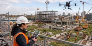
Introduction Drone-mounted LiDAR (Light Detection and Ranging) has revolutionised the way we capture detailed topographic, vegetation, and infrastructure data. The precision and efficiency of LiDAR are unmatched, enabling the rapid …

LiDAR image of construction housebuilding site
LiDAR / Uncategorized

The Powerful Benefits of a LiDAR Survey

In the world of mapping, construction, and environmental monitoring, accuracy is everything — and LiDAR is changing the game. Short for Light Detection and Ranging, LiDAR surveys have become an …

Construction / LiDAR

LiDAR surveys or Photogrammetry – When to use what and where

LiDAR is the buzz word in surveying and drones, but is it the best tool to use in all circumstances? In this article we look at the application of LiDAR …

Housebuilding construction drone image
Construction / Housebuilding / LiDAR

How Drones help prevent conflict in construction

Most organisations don’t publicly discuss conflict they have on projects. Yet, conflicts are an inherent part of the project lifecycle be it a minor verbal matter or large scale litigation. …

Construction / Housebuilding / LiDAR

LiDAR Survey – Forestry

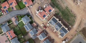
We were recently asked to provide an aerial LiDAR survey of a 25,000m² area of dense forestry. The purpose of the LiDAR survey was to create a digital terrain model, …

Recent Posts

  • 6 Years of Flight: From “Pretty Pictures” to Precision Science at Drone Scotland!
  • Thermal imaging in building surveys
  • LiDAR Drone Surveys: Getting the Right Data at the Right Time
  • Drones in UK Housebuilding – Driving efficiencies
  • Drones and Renewable Energy. Scotland’s Aerial Revolution
Copyright © 2016-2025 Drone Scotland Limited Tel: 0141 302 4685. Glasgow ¦ Tel: 0131 203 3077. Edinburgh ¦ Tel: 01292 518 833. Maybole ¦ Tel: 01382 785 693. Dundee
Hotline
0141 302 4685
We use cookies to ensure that we give you the best experience on our website. If you continue to use this site we will assume that you are happy with it.