
Introduction
Drone-mounted LiDAR (Light Detection and Ranging) has revolutionised the way we capture detailed topographic, vegetation, and infrastructure data. The precision and efficiency of LiDAR are unmatched, enabling the rapid collection of three-dimensional information over large or inaccessible areas. However, the timing of these surveys is crucial for maximizing data quality and survey efficiency. This document explores the best time of year to conduct drone-mounted LiDAR surveys and the reasons why certain seasons offer optimal conditions.
The global LiDAR market is expanding and expected to reach $8.39m in 2033. Airbourne LiDAR systems, mounted on aircraft or drones, accounts for 47% of the total LiDAR market share. In Europe, drone mounted LiDAR accounts for 47% of all LiDAR operations. This is due to it’s ability to capture vast areas of high precision, especially in applications like mapping or surveying. (Global Growth Insights)
The Basics of Drone-Mounted LiDAR Surveys
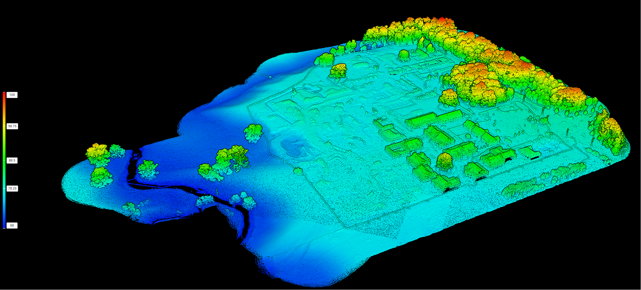
LiDAR operates by emitting laser pulses from a sensor mounted on an aerial platform, such as a drone. These pulses reflect off the ground, vegetation, buildings, and other objects, with the sensor measuring the time it takes for each pulse to return. The result is a dense point cloud representing the surveyed area in three dimensions.
Drone-mounted LiDAR is particularly valued for its:
- Ability to penetrate vegetation canopies and measure ground elevations
- High spatial resolution and accuracy
- Flexibility in covering complex terrain and remote locations
Seasonal Influences on LiDAR Data Quality
While LiDAR can collect data in a broad range of conditions, environmental factors can significantly impact the quality and usefulness of the results. Chief among these are vegetation cover, weather conditions, and sunlight angles, all of which vary throughout the year.
Vegetation Cover
One of the main strengths of LiDAR is its ability to “see through” gaps in the canopy and capture bare earth data, even in forested areas. However, the density of leaves and ground vegetation has a direct effect on how many laser pulses reach the ground.
- Leaf-On Conditions (spring and summer): Trees and shrubs are fully leafed out, creating a dense canopy that can obstruct laser pulses. This reduces the number of ground returns, making it harder to produce accurate bare earth models.
- Leaf-Off Conditions (late autumn, winter, and early spring): Deciduous trees have lost their leaves, dramatically increasing the likelihood that LiDAR pulses will reach the ground. Understory vegetation may also die back, further improving ground visibility.

Drone Scotland
Weather and Atmospheric Conditions
Weather can impact both the logistics and the technical quality of drone LiDAR surveys.
- Cloud Cover and Sun Angle: While LiDAR sensors are not directly affected by sunlight, clear skies and low sun angles (typical in winter) can improve drone visibility and operator safety.
- Rain, Snow, and Fog: Precipitation and heavy moisture in the air can scatter or absorb LiDAR pulses, reducing data quality and increasing noise. Additionally, wet or snowy surfaces may reflect LiDAR differently than dry ground, altering ground classification results.
- Wind: High winds can reduce drone stability and battery efficiency, causing less precise flight lines and potential data inconsistencies.
Ground Surface Conditions
The presence of snow, ice, or standing water can obscure the actual ground surface, making results less reliable for terrain mapping. Bare earth conditions—when the ground is visible and free from snow or heavy leaf litter—are optimal for most surveys.
Best Time of Year for Drone-Mounted LiDAR Surveys
Because of the above factors, the optimal time for drone-mounted LiDAR surveys is typically late autumn through early spring, depending on your geographic region and project goals.
Why Late Autumn to Early Spring?
- Leaf-Off Period: For temperate regions with deciduous forests, late autumn (after leaf fall) to early spring (before bud break) is the prime window. The absence of leaves and reduced understory vegetation allow the maximum number of LiDAR pulses to reach the ground, resulting in high-quality terrain models and more accurate digital elevation models (DEMs).
- Minimal Snow Cover: Scheduling surveys after leaf-off but before significant snowfall avoids the issue of snow obscuring ground features. In regions with little or no snow, the window may be extended into winter.
- Low Agricultural Activity: Many rural or agricultural areas have less crop cover and less field activity during this period, further improving ground visibility.

Exceptions and Project-Specific Considerations
While the leaf-off, snow-free period is generally best for topographic surveys, some projects may require different timing:
- Vegetation Mapping: If the goal is to measure canopy structure, leaf area index, or biomass, a “leaf-on” survey is preferable, as it captures the maximum foliage extent.
- Hydrology and Flood Studies: Early spring may be avoided in areas prone to flooding or standing water, which can obscure the ground surface.
- Urban Environments: In cities with minimal vegetation, surveys can be performed year-round, with weather conditions being the primary consideration.
Regional Variations
The ideal survey period can shift based on local climate:
- Temperate Climates: Late November to early March, when deciduous trees are leafless and snow cover is minimal.
- Arid and Semi-Arid Regions: Any time of year when ground visibility is not compromised by dust storms or rare flushes of vegetation.
- Tropical Climates: Many trees are evergreen and shed leaves at different times, so surveys may require careful scheduling based on dominant species and seasonal rains.
- High-Latitude Locations: The survey window may be short, as snow and ice persist for much of the year. Late summer to early autumn may offer the best compromise.
Planning and Practical Tips
To maximize the success of a drone-mounted LiDAR project, consider the following steps:
- Review historical weather data to identify periods with minimal precipitation and favorable flying conditions.
- Consult vegetation phenology data for your location to pinpoint the leaf-off window.
- Be aware of local regulations regarding drone flights, which may vary seasonally due to wildlife or agricultural activities.
- Coordinate with landowners and stakeholders to ensure site access when fields are not in use.
- Check and calibrate equipment before the leaf-off window, as maintenance delays can cost valuable survey days.
Conclusion
In summary, the best time of year to conduct drone-mounted LiDAR surveys is usually during the leaf-off season—late autumn to early spring—when ground visibility is highest and weather conditions are most favorable for drone operations. By planning surveys around these periods and adjusting for regional variations, you can ensure the highest data quality and most efficient use of resources. Always tailor the timing to the specific goals of your project and the unique environmental conditions of your site.
For more information on how Drone Scotland can assist with your project, contact us at office@dronescotland.com or 0141 302 4685.